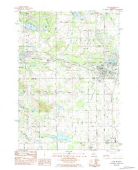
1983 Map of Clare
USGS Topo · Published 1984About this map
The city of Clare serves as the focal point of this 1980s landscape, positioned at the intersection of significant transportation routes and water systems. The Chesapeake and Ohio railroad corridor cuts through the territory, passing north of Farwell and its adjacent Mill Pond. This era captures a transition in rail history, noted by the presence of the Harrison Railroad Grade and the Michigan Northern Ludington and Ohio line. Local landmarks like Cherry Grove Cem and Lake Shamrock define the eastern edge of the settlement near Pettit Park. To the south, the landscape shifts toward the rural townships of Gilmore and Vernon, where water management is evident through the Willow Lake Drain and Little Tobacco Drain. Small communities such as Vernon City and Colonville are documented alongside family-named water bodies like Owens Lake and Stevenson Lake.
Find a feature on this map
53 named features on this map. Tap any name to fly to it.
Don’t see what you’re looking for? This feature index may not catch every label — zoom into the map to look around manually.
Map Details
Editions of this 1983 Clare Map
This is the sole edition of this map. No revisions or reprints were ever made.
Other maps of this area

1916 · Mount Pleasant
USGS Topo · 1:62,500

1919 · Mount Pleasant
USGS Topo · 1:62,500

1930 · Shepherd
USGS Topo · 1:48,000

1936 · Shepherd
USGS Topo · 1:62,500

1943 · Mount Pleasant
USGS Topo · 1:62,500

1954 · Midland
USGS Topo · 1:250,000

1958 · Midland
USGS Topo · 1:250,000

1959 · Midland
USGS Topo · 1:250,000

1959 · Clare
USGS Topo · 1:62,500

1966 · Midland
USGS Topo · 1:250,000