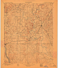
1901 Map of Claremore
USGS Topo · Published 1913About this map
Claremore sits at the center of this landscape during the transition from tribal territories to Oklahoma statehood. This survey documents the complex web of tribal boundaries, including the Osage Nation - Cherokee Nation line and the Cherokee Nation Creek Nation border. The regional economy of the 1890s is visible through the St. Louis and San Francisco RR and the Kansas City and Arkansas Valley Div. tracks, which connect early settlements like Oologah and Inola. Landforms such as Lipe Mound and Claremore Mound break the terrain, while the Verdigris River and Arkansas River serve as primary watercourses. The early footprint of Tulsa is visible on the western edge, along with local landmarks like the Island Ferry crossing and numerous named creeks that define the drainage of the Verdigris valley.
Find a feature on this map
50 named features on this map. Tap any name to fly to it.
Don’t see what you’re looking for? This feature index may not catch every label — zoom into the map to look around manually.
Map Details
Editions of this 1901 Claremore Map
4 editions found
Other maps of this area

1896 · Okmulgee
USGS Topo · 1:125,000

1896 · Pryor
USGS Topo · 1:125,000

1900 · Okmulgee
USGS Topo · 1:125,000

1901 · Muscogee
USGS Topo · 1:125,000

1901 · Claremore
USGS Topo · 1:125,000

1901 · Nowata
USGS Topo · 1:125,000

1901 · Vinita
USGS Topo · 1:125,000

1901 · Pryor
USGS Topo · 1:125,000

1901 · Nuyaka
USGS Topo · 1:125,000

1905 · Muscogee
USGS Topo · 1:125,000