1901 Map of Claremore
USGS Topo · Published 1915About this map
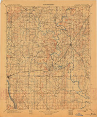
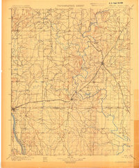
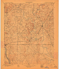
Claremore stands at the heart of this survey of northeastern Indian Territory, where the St. Louis Iron Mountain and Southern meets the St. Louis and San Francisco railroad. The map documents a critical period of settlement and infrastructure before Oklahoma statehood, showing the early layouts of Tulsa, Catoosa, and Oologah. Distinctive topographical landmarks like Lipe Mound and Claremore Mound rise above the drainage basins of the Verdigris River and Bird Creek. Significant tribal boundaries are clearly delineated, including the borders of the Osage Nation, Cherokee Nation, and Creek Nation. The prevalence of river crossings, such as the Island Ferry, and the spiderweb of early wagon roads connecting rural points like Eli and Tarley illustrate the transit patterns of the late nineteenth-century frontier.
Find a feature on this map
47 named features on this map. Tap any name to fly to it.
Don’t see what you’re looking for? This feature index may not catch every label — zoom into the map to look around manually.
Map Details
Editions of this 1901 Claremore Map
4 editions found
Other maps of this area

1896 · Okmulgee
USGS Topo · 1:125,000

1896 · Pryor
USGS Topo · 1:125,000

1900 · Okmulgee
USGS Topo · 1:125,000

1901 · Muscogee
USGS Topo · 1:125,000

1901 · Claremore
USGS Topo · 1:125,000

1901 · Nowata
USGS Topo · 1:125,000

1901 · Vinita
USGS Topo · 1:125,000

1901 · Pryor
USGS Topo · 1:125,000

1901 · Nuyaka
USGS Topo · 1:125,000

1905 · Muscogee
USGS Topo · 1:125,000