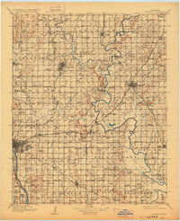
1916 Map of Claremore
USGS Topo · Published 1928About this map
Claremore and the surrounding plains of northeast Oklahoma are shown here as they appeared during a period of rapid development following statehood. The landscape is defined by the major river systems of the Verdigris and the Arkansas River, with the convergence of four major railroads including the Atchison Topeka and Santa Fe and the St Louis and San Francisco. This infrastructure supported a network of growing agricultural and industrial centers like Collinsville, Skiatook, and Broken Arrow.
Find a feature on this map
108 named features on this map. Tap any name to fly to it.
Don’t see what you’re looking for? This feature index may not catch every label — zoom into the map to look around manually.
Map Details
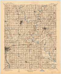
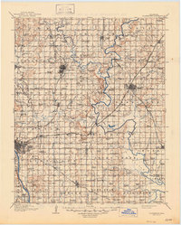
Editions of this 1916 Claremore Map
4 editions found

Other maps of this area

1896 · Okmulgee
USGS Topo · 1:125,000

1896 · Pryor
USGS Topo · 1:125,000

1900 · Okmulgee
USGS Topo · 1:125,000

1901 · Muscogee
USGS Topo · 1:125,000

1901 · Claremore
USGS Topo · 1:125,000

1901 · Nowata
USGS Topo · 1:125,000

1901 · Vinita
USGS Topo · 1:125,000

1901 · Pryor
USGS Topo · 1:125,000

1901 · Nuyaka
USGS Topo · 1:125,000

1905 · Muscogee
USGS Topo · 1:125,000