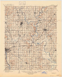
1916 Map of Claremore
USGS Topo · Published 1947About this map
The Verdigris River and Arkansas River define the hydraulic character of this northeastern Oklahoma region during the mid-1910s. This survey, conducted by R.W. Berry, documents the expanding footprint of Tulsa and Claremore before the extensive modernization of the mid-20th century. The landscape is heavily marked by a dense network of country schools, such as Greenwood Chapel and Love School, alongside significant river crossings like Fox Taylor Ford and the Mas Thomas Ferry.
Find a feature on this map
126 named features on this map. Tap any name to fly to it.
Don’t see what you’re looking for? This feature index may not catch every label — zoom into the map to look around manually.
Map Details
Editions of this 1916 Claremore Map
4 editions found

Other maps of this area

1896 · Okmulgee
USGS Topo · 1:125,000

1896 · Pryor
USGS Topo · 1:125,000

1900 · Okmulgee
USGS Topo · 1:125,000

1901 · Muscogee
USGS Topo · 1:125,000

1901 · Claremore
USGS Topo · 1:125,000

1901 · Nowata
USGS Topo · 1:125,000

1901 · Vinita
USGS Topo · 1:125,000

1901 · Pryor
USGS Topo · 1:125,000

1901 · Nuyaka
USGS Topo · 1:125,000

1905 · Muscogee
USGS Topo · 1:125,000