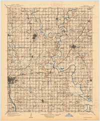
1916 Map of Claremore
USGS Topo · Published 1938About this map
Tulsa and its surrounding prairie landscape are documented during a period of rapid development along the Arkansas River. The region is defined by a dense network of early schools such as Eureka School and Midway School, alongside significant landmarks like Claremore Mound and Lipe Mound. This 1913-1914 survey captures the critical role of rail transport in Northeastern Oklahoma, showing the convergence of the St Louis and San Francisco, Atchison Topeka and Santa Fe, and Missouri Kansas and Texas railroads. These lines connect growing agricultural and resource hubs like Collinsville, Skiatook, and Oolagah. Smaller settlements such as Tiawah and Alsuma appear alongside local industry, including the Sawmill operations and the Blue Cut mine, illustrating the early 20th-century economic foundations of Rogers and Tulsa counties.
Find a feature on this map
125 named features on this map. Tap any name to fly to it.
Don’t see what you’re looking for? This feature index may not catch every label — zoom into the map to look around manually.
Map Details
Editions of this 1916 Claremore Map
4 editions found

Other maps of this area

1896 · Okmulgee
USGS Topo · 1:125,000

1896 · Pryor
USGS Topo · 1:125,000

1900 · Okmulgee
USGS Topo · 1:125,000

1901 · Muscogee
USGS Topo · 1:125,000

1901 · Claremore
USGS Topo · 1:125,000

1901 · Nowata
USGS Topo · 1:125,000

1901 · Vinita
USGS Topo · 1:125,000

1901 · Pryor
USGS Topo · 1:125,000

1901 · Nuyaka
USGS Topo · 1:125,000

1905 · Muscogee
USGS Topo · 1:125,000