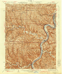
1940 Map of Clarington
USGS Topo · Published 1940About this map
Ohio River commerce and Appalachian industry dominate this 1940 survey of the borderlands between Ohio and West Virginia. The river corridor is a hive of activity, featuring the Baltimore and Ohio Railroad and the Cleveland and Pittsburgh Div line connecting river towns like Moundsville and Powhatan Point. In the interior, the landscape transitions to the deeply carved valleys of Captina Creek and Sunfish Creek, where rural life is anchored by several country schools including Welcome Sch and Burch Sch.
Find a feature on this map
87 named features on this map. Tap any name to fly to it.
Don’t see what you’re looking for? This feature index may not catch every label — zoom into the map to look around manually.
Map Details
Editions of this 1940 Clarington Map
This is the sole edition of this map. No revisions or reprints were ever made.
Other maps of this area

1902 · Wheeling
USGS Topo · 1:62,500

1903 · Littleton
USGS Topo · 1:62,500
1903 · Flushing
USGS Topo · 1:62,500

1904 · Cameron
USGS Topo · 1:62,500

1905 · Littleton
USGS Topo · 1:62,500
1905 · Clarington
USGS Topo · 1:62,500
1905 · New Matamoras
USGS Topo · 1:62,500

1905 · St. Clairsville
USGS Topo · 1:62,500
1905 · Woodsfield
USGS Topo · 1:62,500
1905 · Flushing
USGS Topo · 1:62,500