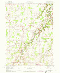
1960 Map of Clarksfield
USGS Topo · Published 1973About this map
The Vermilion River carves a deeply incised path through the rural landscape of central Huron County, creating a distinctive meandering drainage pattern that dictates the placement of early roads and homesteads. This 1960s survey captures the region as it transitioned from traditional agriculture to a modern rural-industrial mix, evidenced by the presence of a Landing Strip and an active Pipeline alongside established townships. Local history and genealogy are well-represented by numerous historic burial grounds, including East Townsend Cem, Hartland Ridge Cem, Collinswood Cem, and Township Cem. The northern portion of the map is anchored by the community of Wakeman, while the Norfolk and Western railway corridor provides a sharp east-west industrial line across the townships of Townsend, Hartland, and Clarksfield. Small rural nodes like West Clarksfield and Hartland Station remain visible, reflecting the era's rail-dependent settlement patterns.
Find a feature on this map
31 named features on this map. Tap any name to fly to it.
Don’t see what you’re looking for? This feature index may not catch every label — zoom into the map to look around manually.
Map Details
Editions of this 1960 Clarksfield Map
2 editions found
Other maps of this area

1903 · Vermilion
USGS Topo · 1:62,500

1904 · Sandusky
USGS Topo · 1:62,500

1908 · New London
USGS Topo · 1:62,500

1915 · Norwalk
USGS Topo · 1:62,500

1944 · Norwalk
USGS Topo · 1:62,500

1956 · Toledo
USGS Topo · 1:250,000

1959 · Milan
USGS Topo · 1:24,000

1959 · Berlin Heights
USGS Topo · 1:24,000

1959 · Kipton
USGS Topo · 1:24,000

1960 · New London
USGS Topo · 1:24,000