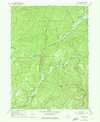
1966 Map of Claryville
USGS Topo · Published 1974About this map
The West Branch Neversink River and East Branch Neversink River converge near the heart of this mid-1960s Catskill landscape, centering on the small settlement of Claryville. Much of the terrain is defined by the Catskill Park and numerous tracts of the State Forest Preserve, including the Hardenbergh State Forest Preserve and Neversink State Forest Preserve. This intersection of protected wilderness and local community is physically marked by high peaks such as Denman Mountain and Red Hill, the latter featuring a distinct Lookout Tower.
Find a feature on this map
31 named features on this map. Tap any name to fly to it.
Don’t see what you’re looking for? This feature index may not catch every label — zoom into the map to look around manually.
Map Details
Editions of this 1966 Claryville Map
Other maps of this area

1900 · Phoenicia
USGS Topo · 1:62,500

1901 · Margaretville
USGS Topo · 1:62,500

1903 · Phoenicia
USGS Topo · 1:62,500

1903 · Slide Mountain
USGS Topo · 1:62,500

1904 · Margaretville
USGS Topo · 1:62,500

1905 · Slide Mountain
USGS Topo · 1:62,500

1910 · Neversink
USGS Topo · 1:62,500

1942 · Neversink
USGS Topo · 1:62,500

1942 · Lackawack
USGS Topo · 1:24,000

1943 · Peekamoose Mountain
USGS Topo · 1:31,680