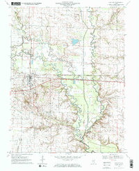
1970 Map of Clay City
USGS Topo · Published 1971About this map
The Little Wabash River meanders across this landscape, defining the topography of Clay and Richland counties during a period of significant industrial activity. The Clay City Oil Field dominates the central and southern portions of the map, marked by extensive well sites and a network of service roads. The town of Clay City serves as the regional hub, situated along the Baltimore and Ohio railroad corridor.
Find a feature on this map
25 named features on this map. Tap any name to fly to it.
Don’t see what you’re looking for? This feature index may not catch every label — zoom into the map to look around manually.
Map Details
Editions of this 1970 Clay City Map
2 editions found
Other maps of this area

1941 · Newton
USGS Topo · 1:62,500

1943 · Newton
USGS Topo · 1:62,500

1948 · Flora
USGS Topo · 1:62,500

1949 · Olney
USGS Topo · 1:62,500

1949 · Flora
USGS Topo · 1:62,500

1953 · Sailor Springs
USGS Topo · 1:62,500

1958 · Belleville
USGS Topo · 1:250,000

1962 · Belleville
USGS Topo · 1:250,000

1970 · Clay City
USGS Topo · 1:24,000

1970 · Enterprise
USGS Topo · 1:24,000