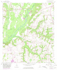
1957 Map of Clayhatchee
USGS Topo · Published 1981About this map
The Choctawhatchee River dominates the landscape of southeastern Alabama in this 1950s survey, updated with revisions from the late 1970s. The river's winding course forms the natural boundary between Dale, Houston, and Geneva counties, creating a complex network of drainages including Hurricane Creek and Claybank Creek. This area preserves evidence of long-term human habitation, notably the Indian Mound situated on a bend of the river south of Clayhatchee.
Find a feature on this map
33 named features on this map. Tap any name to fly to it.
Don’t see what you’re looking for? This feature index may not catch every label — zoom into the map to look around manually.
Map Details
Editions of this 1957 Clayhatchee Map
4 editions found
Other maps of this area

1942 · Enterprise
USGS Topo · 1:125,000

1948 · Ozark
USGS Topo · 1:62,500

1950 · Ozark
USGS Topo · 1:62,500

1950 · Enterprise
USGS Topo · 1:62,500

1953 · Dothan
USGS Topo · 1:250,000

1954 · Dothan
USGS Topo · 1:250,000

1955 · Dothan
USGS Topo · 1:250,000

1957 · Malvern
USGS Topo · 1:24,000

1957 · Geneva
USGS Topo · 1:62,500

1957 · Hartford
USGS Topo · 1:62,500