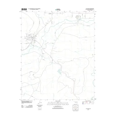
2012 Map of Clayton
USGS Topo · Published 2012About this map
Clayton and Tuskahoma anchor this southeastern Oklahoma landscape at the confluence of the Jackfork and the Kiamichi River. The map details the local road network, including numerous rural routes such as 9 Pine Rd and Ritter Rd, which serve the small communities and recreational areas. For those researching local heritage, the Clayton Old Town Cem provides a specific point of interest near the town center. The terrain is defined by a dense network of waterways, including Peal Cr, Hurd Cr, and Black Fork, which flow toward Clayton Lake. This survey also identifies A L Stephens Memorial Park, a significant local landmark situated north of the main settlement area near the Kiamichi. The detailed plotting of individual street names in Clayton, like Van Horn St and Chancellor Ln, provides a clear view of the town's modern footprint.
Find a feature on this map
53 named features on this map. Tap any name to fly to it.
Don’t see what you’re looking for? This feature index may not catch every label — zoom into the map to look around manually.
Map Details
Editions of this 2012 Clayton Map
This is the sole edition of this map. No revisions or reprints were ever made.
Other maps of this area

1901 · Tuskahoma
USGS Topo · 1:125,000

1901 · Alikchi
USGS Topo · 1:125,000

1908 · Tuskahoma
USGS Topo · 1:125,000

1909 · Tuskahoma
USGS Topo · 1:125,000

1950 · Mcalester
USGS Topo · 1:250,000

1962 · McAlester
USGS Topo · 1:250,000

1965 · McAlester
USGS Topo · 1:250,000

1971 · Yanush
USGS Topo · 1:24,000

1971 · Kiamichi
USGS Topo · 1:24,000
1971 · Sardis
USGS Topo · 1:24,000