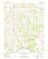
1974 Map of Clear Creek
USGS Topo · Published 1977About this map
The Cimarron River winds along the southern edge of this mid-1970s landscape, defining the boundary between Logan and Payne counties. This territory is marked by a complex network of active extraction, featuring an Oil Field and numerous Oil Wells, Drill Holes, and a Gravel Pit that speak to the region's industrial foundations. The rural social fabric is anchored by landmarks such as the Vassar Ch, while genealogy researchers can locate the Morris Heights Cem and Clarkson Cem within the northern and southern townships respectively.
Find a feature on this map
27 named features on this map. Tap any name to fly to it.
Don’t see what you’re looking for? This feature index may not catch every label — zoom into the map to look around manually.
Map Details
Editions of this 1974 Clear Creek Map
This is the sole edition of this map. No revisions or reprints were ever made.
Other maps of this area

1892 · Guthrie
USGS Topo · 1:62,500

1893 · Mulhall
USGS Topo · 1:62,500

1893 · Stillwater
USGS Topo · 1:62,500

1909 · Perkins
USGS Topo · 1:62,500

1954 · Oklahoma City
USGS Topo · 1:250,000

1955 · Enid
USGS Topo · 1:250,000

1957 · Oklahoma City
USGS Topo · 1:250,000

1958 · Enid
USGS Topo · 1:250,000

1963 · Oklahoma City
USGS Topo · 1:250,000

1966 · Lake Carl Blackwell
USGS Topo · 1:24,000