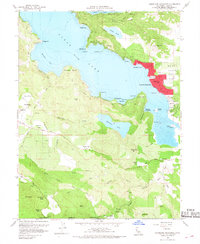
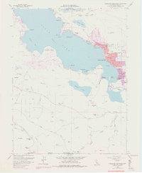
1958 Map of Clearlake Highlands
USGS Topo · Published 1968About this map
The southeastern shoreline of Clear Lake dominates this mid-century survey, revealing a landscape transitioning between lakeside recreation and industrial resource extraction. Post-war development is concentrated around Clearlake Highlands and Clearlake Park, where a dense network of residential streets like Olympia Ave and Austin Ave serves the growing community. Local education is anchored by Burns Valley Sch, while the area's entertainment culture is represented by the local Drive-in Theatre.
Find a feature on this map
70 named features on this map. Tap any name to fly to it.
Don’t see what you’re looking for? This feature index may not catch every label — zoom into the map to look around manually.
Map Details
Editions of this 1958 Clearlake Highlands Map
5 editions found
Other maps of this area

1921 · Kelseyville
USGS Topo · 1:62,500

1924 · Bartlett Springs
USGS Topo · 1:62,500

1938 · Lakeport
USGS Topo · 1:62,500

1942 · Bartlett Springs
USGS Topo · 1:62,500

1943 · Kelseyville
USGS Topo · 1:62,500

1944 · Bartlett Springs
USGS Topo · 1:62,500

1945 · Lower Lake
USGS Topo · 1:62,500

1947 · Santa Rosa
USGS Topo · 1:250,000

1949 · Santa Rosa
USGS Topo · 1:250,000

1951 · Lakeport
USGS Topo · 1:62,500