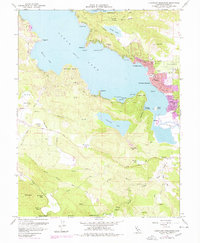
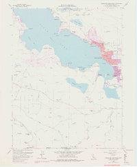
1958 Map of Clearlake Highlands
USGS Topo · Published 1978About this map
The south shore of Clear Lake serves as a vibrant focal point for development in the Lake County hills during the mid-20th century. The communities of Clearlake Highlands and Clearlake Park show significant expansion, anchored by Burns Valley and the Burns Valley Sch. This era captures the region's character as both an industrial site and a recreational destination, with the Sulphur Bank mine situated near the shores of Borax Lake while specialized retreats like Salminas Resort and Mt Hannah Lodge occupy the higher elevations to the south. The presence of two airfields, Hoberg Airport and Pearce Airport, suggests a landscape increasingly connected by air travel. Between the shoreline and the peaks of Seigler Mtn and Mt Hannah, a complex network of seasonal lakes including Thurston Lake and Dry Lake punctuates the terrain, illustrating the unique drainage patterns that define this volcanic geography.
Find a feature on this map
58 named features on this map. Tap any name to fly to it.
Don’t see what you’re looking for? This feature index may not catch every label — zoom into the map to look around manually.
Map Details
Editions of this 1958 Clearlake Highlands Map
5 editions found
Other maps of this area

1921 · Kelseyville
USGS Topo · 1:62,500

1924 · Bartlett Springs
USGS Topo · 1:62,500

1938 · Lakeport
USGS Topo · 1:62,500

1942 · Bartlett Springs
USGS Topo · 1:62,500

1943 · Kelseyville
USGS Topo · 1:62,500

1944 · Bartlett Springs
USGS Topo · 1:62,500

1945 · Lower Lake
USGS Topo · 1:62,500

1947 · Santa Rosa
USGS Topo · 1:250,000

1949 · Santa Rosa
USGS Topo · 1:250,000

1951 · Lakeport
USGS Topo · 1:62,500