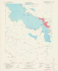
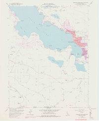
1958 Map of Clearlake Highlands
USGS Topo · Published 1968About this map
Clear Lake dominates this mid-century landscape, framing the growing communities of Clearlake Highlands and Clearlake Park along its southeastern shores. The map captures a transition between the established extraction economy, evidenced by the Sulphur Bank and several gravel pits, and the burgeoning recreational identity of the region. Local landmarks like the Burns Valley Sch and Peacock Pt anchor the residential developments, while the presence of Salminas Resort and Mt Hannah Lodge near Mt Hannah highlights the area's appeal to visitors. The intricate shoreline is defined by named features such as Konocti Bay, Jones Bay, and Jago Bay, alongside small land masses like Indian Island and Garner I. Further inland, the terrain rises toward Seigler Mtn and Bald Mtn, with smaller water bodies like Borax Lake and Thurston Lake scattered through the valleys.
Find a feature on this map
60 named features on this map. Tap any name to fly to it.
Don’t see what you’re looking for? This feature index may not catch every label — zoom into the map to look around manually.
Map Details
Editions of this 1958 Clearlake Highlands Map
5 editions found
Other maps of this area

1921 · Kelseyville
USGS Topo · 1:62,500

1924 · Bartlett Springs
USGS Topo · 1:62,500

1938 · Lakeport
USGS Topo · 1:62,500

1942 · Bartlett Springs
USGS Topo · 1:62,500

1943 · Kelseyville
USGS Topo · 1:62,500

1944 · Bartlett Springs
USGS Topo · 1:62,500

1945 · Lower Lake
USGS Topo · 1:62,500

1947 · Santa Rosa
USGS Topo · 1:250,000

1949 · Santa Rosa
USGS Topo · 1:250,000

1951 · Lakeport
USGS Topo · 1:62,500