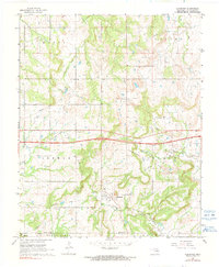
1967 Map of Clearview
USGS Topo · Published 1991About this map
Clearview serves as the focal point of this Okfuskee County landscape, surrounded by an extensive network of petroleum extraction sites that defined the local economy during the mid-20th century. Numerous named zones, including the NW Clearview Oil and Gas Field and the Lyons-Quinn Oil and Gas Field, illustrate the dense industrial footprint across the region. These fields are interspersed with local landmarks like Hickory Ridge and the Philadelphia Creek valley.
Find a feature on this map
26 named features on this map. Tap any name to fly to it.
Don’t see what you’re looking for? This feature index may not catch every label — zoom into the map to look around manually.
Map Details
Editions of this 1967 Clearview Map
2 editions found
Other maps of this area

1900 · Wewoka
USGS Topo · 1:125,000

1901 · Nuyaka
USGS Topo · 1:125,000

1954 · Oklahoma City
USGS Topo · 1:250,000

1957 · Oklahoma City
USGS Topo · 1:250,000

1963 · Oklahoma City
USGS Topo · 1:250,000
1967 · Pharoah
USGS Topo · 1:24,000

1967 · Okemah SE
USGS Topo · 1:24,000

1967 · Weleetka
USGS Topo · 1:24,000

1967 · Okemah
USGS Topo · 1:24,000
1967 · Clearview
USGS Topo · 1:24,000