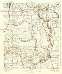
1934 Map of Cleveland
USGS Topo · Published 1934About this map
The Yazoo and Mississippi Valley Railroad serves as the primary spine for this Mississippi Delta landscape, connecting the growing hub of Cleveland with agricultural communities like Boyle, Ruleville, and Moorhead. This survey, compiled from aerial photographs by the U.S. Army Air Corps, captures a territory transitioning from dense swamplands to a highly organized plantation economy. The interior is defined by a complex drainage network including Howling Wolf Bayou and Standing Stump Bayou, while the Sunflower River and Yazoo River meander along the eastern and southern reaches.
Find a feature on this map
87 named features on this map. Tap any name to fly to it.
Don’t see what you’re looking for? This feature index may not catch every label — zoom into the map to look around manually.
Map Details
Editions of this 1934 Cleveland Map
2 editions found
Other maps of this area

1931 · Schlater
USGS Topo · 1:48,000

1931 · Sumner
USGS Topo · 1:48,000

1931 · Drew
USGS Topo · 1:48,000

1934 · Cleveland
USGS Topo · 1:62,500

1934 · Schlater
USGS Topo · 1:62,500

1935 · Sumner
USGS Topo · 1:62,500

1935 · Mound Bayou
USGS Topo · 1:62,500

1939 · Schlater
USGS Topo · 1:62,500

1939 · Pace
USGS Topo · 1:62,500

1939 · Sumner
USGS Topo · 1:62,500