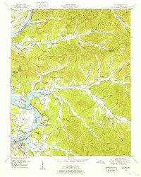
1949 Map of Clifton
USGS Topo · Published 1952About this map
Clifton serves as the focal point of this riverfront survey, positioned along a sharp bend where the Tennessee River transitions into the expansive Kentucky Lake. The landscape is defined by the river’s winding course, featuring numerous islands and towheads such as Beech Creek Island and Russ Towhead. This postwar era documentation highlights a transition in river activity, with established sites like Lego Landing and Glenkirk Landing alongside newer infrastructure like the Clifton Airport and a Gaging station near the water's edge.
Find a feature on this map
85 named features on this map. Tap any name to fly to it.
Don’t see what you’re looking for? This feature index may not catch every label — zoom into the map to look around manually.
Map Details
Editions of this 1949 Clifton Map
4 editions found
Other maps of this area

1905 · Waynesboro
USGS Topo · 1:125,000

1936 · Eagle Creek
USGS Topo · 1:24,000

1936 · Olivehill
USGS Topo · 1:24,000

1936 · Bath Springs
USGS Topo · 1:24,000

1936 · Linden
USGS Topo · 1:24,000

1936 · Leatherwood
USGS Topo · 1:24,000

1936 · Clifton
USGS Topo · 1:24,000

1936 · Perryville
USGS Topo · 1:24,000

1936 · Waynesboro
USGS Topo · 1:24,000

1936 · Pope
USGS Topo · 1:24,000