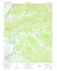
1949 Map of Clifton
USGS Topo · Published 1973About this map
The Tennessee River snakes through the heart of this mid-century survey, defining the boundaries where Decatur, Perry, and Wayne counties meet. The landscape is dominated by the flooded expanse of Kentucky Lake, which submerged earlier riverfront terrain and created landmarks like Beech Creek Island and Glenkirk Island. While the town of Clifton serves as the primary hub, the surrounding ridges and hollows are dotted with small, family-centered landmarks and community centers.
Find a feature on this map
83 named features on this map. Tap any name to fly to it.
Don’t see what you’re looking for? This feature index may not catch every label — zoom into the map to look around manually.
Map Details
Editions of this 1949 Clifton Map
4 editions found
Other maps of this area

1905 · Waynesboro
USGS Topo · 1:125,000

1936 · Eagle Creek
USGS Topo · 1:24,000

1936 · Olivehill
USGS Topo · 1:24,000

1936 · Bath Springs
USGS Topo · 1:24,000

1936 · Linden
USGS Topo · 1:24,000

1936 · Leatherwood
USGS Topo · 1:24,000

1936 · Clifton
USGS Topo · 1:24,000

1936 · Perryville
USGS Topo · 1:24,000

1936 · Waynesboro
USGS Topo · 1:24,000

1936 · Pope
USGS Topo · 1:24,000