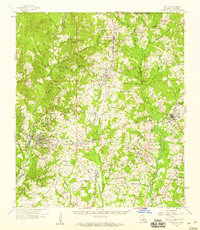
1958 Map of Clinton
USGS Topo · Published 1959About this map
Clinton and Jackson anchor this late-1950s landscape in East Feliciana Parish, where the local economy and social structure are reflected in an extensive network of rural churches and family cemeteries. The Illinois Central railroad corridor connects the northern settlements of Norwood and Wilson down through McManus and Ethel. Notable institutional landmarks include the Louisiana State Hospital and its associated residential areas, State Hospital Colony No 1 and State Hospital Colony No 2.
Find a feature on this map
106 named features on this map. Tap any name to fly to it.
Don’t see what you’re looking for? This feature index may not catch every label — zoom into the map to look around manually.
Map Details
Editions of this 1958 Clinton Map
3 editions found
Other maps of this area

1906 · Bayou Sara
USGS Topo · 1:125,000

1936 · Woodville
USGS Topo · 1:62,500

1939 · St. Francisville
USGS Topo · 1:62,500

1939 · Zachary
USGS Topo · 1:62,500

1941 · Woodland
USGS Topo · 1:31,680

1941 · Norwood
USGS Topo · 1:31,680

1941 · Lost Creek
USGS Topo · 1:31,680

1942 · Pride
USGS Topo · 1:31,680

1945 · Norwood
USGS Topo · 1:31,680

1945 · Jackson
USGS Topo · 1:31,680