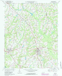
1973 Map of Coats
USGS Topo · Published 1987About this map
The Durham and Southern railway cuts through the heart of this Harnett County landscape, connecting rural communities like Angier and Barclaysville as they appeared in the early 1970s. The region is defined by a dense network of watercourses, including the Black River and Thorntons Creek, which wind through agricultural lands dotted with local landmarks. Significant cultural institutions are anchored here, most notably Campbell College in Buies Creek, providing a focal point for the surrounding settlements.
Find a feature on this map
31 named features on this map. Tap any name to fly to it.
Don’t see what you’re looking for? This feature index may not catch every label — zoom into the map to look around manually.
Map Details
Editions of this 1973 Coats Map
3 editions found
Other maps of this area

1953 · Raleigh
USGS Topo · 1:250,000

1954 · Raleigh
USGS Topo · 1:250,000

1956 · Bunnlevel
USGS Topo · 1:24,000

1964 · Angier
USGS Topo · 1:24,000

1964 · Edmondson
USGS Topo · 1:24,000

1964 · Garner
USGS Topo · 1:62,500

1973 · Benson
USGS Topo · 1:24,000

1973 · Dunn
USGS Topo · 1:24,000

1973 · Erwin
USGS Topo · 1:24,000

1973 · Coats
USGS Topo · 1:24,000