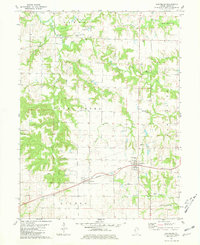
1981 Map of Coatsburg
USGS Topo · Published 1981About this map
Coatsburg and Paloma serve as the primary hubs of activity in this section of Adams County, situated along the Burlington Northern railroad line. The landscape is defined by a dense network of watercourses, including South Fork Bear Creek, Honey Creek, and Bigneck Creek, which carve through the terrain and dictate the placement of early rural infrastructure. Evidence of small-scale aviation and local governance is found in features like the Mealiff Landing Strip and a Townhall located north of Honey Creek. For genealogists, the map is particularly detailed regarding burial grounds, marking several family and community sites such as Gray Mount Cem, Paloma Cem, Byler Cem, and Laugh Cem. This 1981 edition captures the township structure of Keene, Houston, and Gilmer at a time when the rural economy remained tied to the rail corridor and traditional land divisions like the Base Line.
Find a feature on this map
29 named features on this map. Tap any name to fly to it.
Don’t see what you’re looking for? This feature index may not catch every label — zoom into the map to look around manually.
Map Details
Editions of this 1981 Coatsburg Map
This is the sole edition of this map. No revisions or reprints were ever made.
Other maps of this area

1925 · Quincy
USGS Topo · 1:62,500

1925 · Liberty
USGS Topo · 1:62,500

1927 · Liberty
USGS Topo · 1:62,500

1944 · Quincy
USGS Topo · 1:62,500

1945 · Quincy
USGS Topo · 1:62,500

1946 · Mendon
USGS Topo · 1:62,500

1948 · Quincy
USGS Topo · 1:250,000

1948 · Mendon
USGS Topo · 1:62,500

1948 · Camp Point
USGS Topo · 1:62,500

1956 · Quincy
USGS Topo · 1:250,000