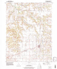
1995 Map of Coatsburg
USGS Topo · Published 1997About this map
Coatsburg and Paloma anchor this mid-1990s landscape in Adams County, where the agricultural plains of western Illinois are deeply incised by the drainage systems of the Mississippi River basin. The terrain is defined by a dendritic network of waterways, including South Fork Bear Creek and Honey Creek, which carve through the townships of Honey Creek, Keene, and Gilmer. This survey illustrates a rural infrastructure centered on established family and community burial grounds, such as Gray Mount Cem and Gooding Cem, which provide essential points of reference for genealogists. The map also records the transit corridors that link these small settlements, showing how the local road network navigates the breaks between elevated farmland and the wooded draws of Brushy Creek and Elm Creek.
Find a feature on this map
24 named features on this map. Tap any name to fly to it.
Don’t see what you’re looking for? This feature index may not catch every label — zoom into the map to look around manually.
Map Details
Editions of this 1995 Coatsburg Map
This is the sole edition of this map. No revisions or reprints were ever made.
Other maps of this area

1925 · Quincy
USGS Topo · 1:62,500

1925 · Liberty
USGS Topo · 1:62,500

1927 · Liberty
USGS Topo · 1:62,500

1944 · Quincy
USGS Topo · 1:62,500

1945 · Quincy
USGS Topo · 1:62,500

1946 · Mendon
USGS Topo · 1:62,500

1948 · Quincy
USGS Topo · 1:250,000

1948 · Mendon
USGS Topo · 1:62,500

1948 · Camp Point
USGS Topo · 1:62,500

1956 · Quincy
USGS Topo · 1:250,000