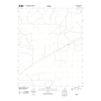
2010 Map of Coburn
USGS Topo · Published 2010About this map
Coburn sits as the primary settlement in this stretch of the Texas Panhandle, positioned along a diagonal transportation corridor. The landscape is defined by the drainage of Canyon Creek, which cuts through the high plains toward the north. This 2010 survey reflects a rural infrastructure built on ranching and energy, where local routes like Bill Hext and Co Rd 18 provide essential connectivity between scattered homesteads and pastures. The presence of Ranch Rd 2758 at the southern edge suggests the importance of state-maintained access to this remote agricultural region. The map reveals the intricate network of windmills and water tanks that sustain life in this semi-arid environment, illustrating the ongoing relationship between the land and its modern inhabitants.
Find a feature on this map
5 named features on this map. Tap any name to fly to it.
Don’t see what you’re looking for? This feature index may not catch every label — zoom into the map to look around manually.
Map Details
Editions of this 2010 Coburn Map
This is the sole edition of this map. No revisions or reprints were ever made.
Other maps of this area

1954 · Perryton
USGS Topo · 1:250,000

1954 · Amarillo
USGS Topo · 1:250,000

1958 · Perryton
USGS Topo · 1:250,000

1958 · Amarillo
USGS Topo · 1:250,000

1972 · Canadian East
USGS Topo · 1:24,000
1972 · Higgins North
USGS Topo · 1:24,000

1972 · Glazier
USGS Topo · 1:24,000

1972 · Willow Creek
USGS Topo · 1:24,000
1972 · Lake Marvin
USGS Topo · 1:24,000
1972 · Dreyfoos
USGS Topo · 1:24,000