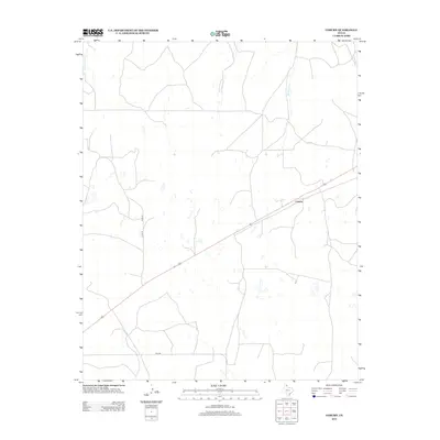
2012 Map of Coburn
USGS Topo · Published 2012About this map
Coburn serves as the central point of reference in this corner of the Texas Panhandle, positioned along a straight stretch of the primary highway. The landscape is defined by the intermittent drainage of the High Plains, where Cottonwood Cr and Canyon Cr cut shallow paths through the terrain. The map details a network of rural transport, from state-maintained routes like Fm-2758 to local section-line roads such as Cord-18 and Cord-19. This 2012 survey illustrates the sparse, late-twentieth-century settlement pattern of Lipscomb County, where long-established ranching and agricultural tracts are accessed by a grid of county roads that follow the flat, open geography of the region.
Find a feature on this map
6 named features on this map. Tap any name to fly to it.
Don’t see what you’re looking for? This feature index may not catch every label — zoom into the map to look around manually.
Map Details
Editions of this 2012 Coburn Map
This is the sole edition of this map. No revisions or reprints were ever made.
Other maps of this area

1954 · Perryton
USGS Topo · 1:250,000

1954 · Amarillo
USGS Topo · 1:250,000

1958 · Perryton
USGS Topo · 1:250,000

1958 · Amarillo
USGS Topo · 1:250,000

1972 · Canadian East
USGS Topo · 1:24,000
1972 · Higgins North
USGS Topo · 1:24,000

1972 · Glazier
USGS Topo · 1:24,000

1972 · Willow Creek
USGS Topo · 1:24,000
1972 · Lake Marvin
USGS Topo · 1:24,000
1972 · Dreyfoos
USGS Topo · 1:24,000