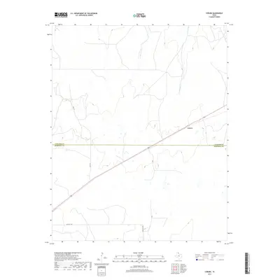
2019 Map of Coburn
USGS Topo · Published 2019About this map
Coburn sits atop the high plains of the Texas Panhandle, positioned precisely where the northern edge of the Hemphill Co line meets Lipscomb Co. This 2019 survey documents a landscape defined by expansive ranch lands and the winding course of Canyon Cr, which cuts through the terrain to the northeast. The area is intersected by a network of local connectors including Co Rd 18 and Ranch Rd 2758, reflecting the enduring rural infrastructure of these border counties. The map provides a clear look at the modern topography of this remote region, where wide-open cattle country remains the primary characteristic of the land.
Find a feature on this map
5 named features on this map. Tap any name to fly to it.
Don’t see what you’re looking for? This feature index may not catch every label — zoom into the map to look around manually.
Map Details
Editions of this 2019 Coburn Map
This is the sole edition of this map. No revisions or reprints were ever made.
Other maps of this area

1954 · Perryton
USGS Topo · 1:250,000

1954 · Amarillo
USGS Topo · 1:250,000

1958 · Perryton
USGS Topo · 1:250,000

1958 · Amarillo
USGS Topo · 1:250,000

1972 · Canadian East
USGS Topo · 1:24,000
1972 · Higgins North
USGS Topo · 1:24,000

1972 · Glazier
USGS Topo · 1:24,000

1972 · Willow Creek
USGS Topo · 1:24,000
1972 · Lake Marvin
USGS Topo · 1:24,000
1972 · Dreyfoos
USGS Topo · 1:24,000