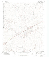
1972 Map of Coburn
USGS Topo · Published 1975About this map
Coburn sits along the rail line in the Texas Panhandle, a landscape defined by the drainage systems of Cottonwood Creek and Canyon Creek. This early 1970s survey illustrates a region where the traditional cattle country of the High Plains is overlaid with a developing energy infrastructure. The Atchison Topeka and Santa Fe railroad bisects the terrain diagonally, serving as the primary corridor through the northern edge of the Lipscomb Co Hemphill Co boundary. Industrial development is evident through numerous Oil Wells, a Gas Well, and a central Pumping Sta, connected by an extensive network of pipelines. The map captures the quiet intersection of ranching geography and the extraction economy, showing how service points like Coburn functioned within the vast open spaces of the Eastern Panhandle.
Find a feature on this map
9 named features on this map. Tap any name to fly to it.
Don’t see what you’re looking for? This feature index may not catch every label — zoom into the map to look around manually.
Map Details
Editions of this 1972 Coburn Map
This is the sole edition of this map. No revisions or reprints were ever made.
Other maps of this area

1954 · Perryton
USGS Topo · 1:250,000

1954 · Amarillo
USGS Topo · 1:250,000

1958 · Perryton
USGS Topo · 1:250,000

1958 · Amarillo
USGS Topo · 1:250,000

1972 · Canadian East
USGS Topo · 1:24,000
1972 · Higgins North
USGS Topo · 1:24,000

1972 · Glazier
USGS Topo · 1:24,000

1972 · Willow Creek
USGS Topo · 1:24,000
1972 · Lake Marvin
USGS Topo · 1:24,000
1972 · Dreyfoos
USGS Topo · 1:24,000