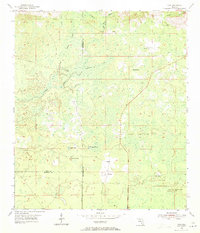
1954 Map of Cody
USGS Topo · Published 1971About this map
St Marks River meanders through the lowlands of Jefferson, Leon, and Wakulla counties, defining a landscape of complex hydrology and sparse settlement. In the early 1950s, this area was characterized by its karst features and seasonal wetlands, with prominent geologic markers like Florida Sink and Hardy Sink punctuating the terrain. Small rural hubs such as Cody and Fanlew anchor the interior, connected by a network of unimproved roads and private tracks that navigate around vast natural features like Gum Swamp.
Find a feature on this map
15 named features on this map. Tap any name to fly to it.
Don’t see what you’re looking for? This feature index may not catch every label — zoom into the map to look around manually.
Map Details
Editions of this 1954 Cody Map
2 editions found
Other maps of this area

1954 · Lloyd
USGS Topo · 1:24,000

1954 · Lafayette
USGS Topo · 1:24,000

1954 · Cody
USGS Topo · 1:24,000

1954 · Woodville
USGS Topo · 1:24,000

1954 · St. Marks NE
USGS Topo · 1:24,000

1954 · St. Marks
USGS Topo · 1:24,000

1954 · Valdosta
USGS Topo · 1:250,000

1954 · Tallahassee
USGS Topo · 1:250,000

1955 · Waukeenah
USGS Topo · 1:24,000

1955 · Nutall Rise
USGS Topo · 1:24,000