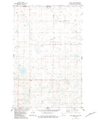
1983 Map of Colgan East
USGS Topo · Published 1984About this map
The international border between the United States and Canada defines the northern edge of this Divide County landscape, where North Dakota meets Saskatchewan. The small settlement of Colgan sits at the heart of the prairie, characterized by the Soo railroad line and a network of agricultural infrastructure. Grain Storage Bins are scattered across the township lines, marking the vital centers of this rural economy. To the south, the terrain becomes more distinct with the landforms of Lincoln Valley and Twin Butte, while the northern reaches include the named areas of Gooseneck and Ambrose. This survey captures the precise grid of the high plains just before the late 20th-century shifts in rail service and farming practices, including local water features like the Flowing Well near the eastern boundary.
Find a feature on this map
13 named features on this map. Tap any name to fly to it.
Don’t see what you’re looking for? This feature index may not catch every label — zoom into the map to look around manually.
Map Details
Editions of this 1983 Colgan East Map
This is the sole edition of this map. No revisions or reprints were ever made.
Other maps of this area

1948 · Crosby SW
USGS Topo · 1:24,000

1948 · Ambrose
USGS Topo · 1:24,000

1950 · Crosby
USGS Topo · 1:62,500

1953 · Williston
USGS Topo · 1:250,000

1957 · Williston
USGS Topo · 1:250,000

1983 · Colgan West
USGS Topo · 1:24,000

1983 · Alexandria
USGS Topo · 1:24,000
1983 · Colgan SE
USGS Topo · 1:24,000

1984 · Crosby
USGS Topo · 1:100,000
2011 · Colgan SE
USGS Topo · 1:24,000