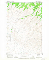
1966 Map of Colockum Pass SE
USGS Topo · Published 1967About this map
Whiskey Dick Mtn dominates the eastern landscape of this Kittitas County survey, which reveals the transition from high ridgelines down into the northeastern reach of the Kittitas Valley. The drainage system is particularly well-defined, showing the paths of Sheep Creek, Little Caribou Creek, and Whiskey Jim Creek as they cut through complex terrain. A series of family-named roads including Cristensen Road, Grinrod Road, and Lyons Road delineate local land use and property access points during the mid-1960s. The presence of a Pipeline Road and a Substation near the southern boundary reflects the development of utility infrastructure across this rural expanse. Genealogists and local historians can use these specific roadway and landmark labels to pinpoint locations within the rugged corridors of Cooke Canyon and Caribou Canyon.
Find a feature on this map
23 named features on this map. Tap any name to fly to it.
Don’t see what you’re looking for? This feature index may not catch every label — zoom into the map to look around manually.
Map Details
Editions of this 1966 Colockum Pass SE Map
This is the sole edition of this map. No revisions or reprints were ever made.
Other maps of this area

1920 · Colockum Pass
USGS Topo · 1:125,000

1922 · Colockum Pass
USGS Topo · 1:125,000

1938 · Badger Pocket
USGS Topo · 1:48,000

1939 · Boylston
USGS Topo · 1:48,000

1943 · Boylston
USGS Topo · 1:62,500

1943 · Badger Pocket
USGS Topo · 1:62,500

1950 · Yakima
USGS Topo · 1:250,000
1953 · East Kittitas
USGS Topo · 1:24,000

1953 · Kittitas
USGS Topo · 1:24,000
1953 · Boylston
USGS Topo · 1:24,000