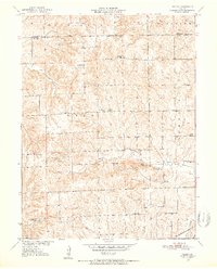
1950 Map of Coloma
USGS Topo · Published 1952About this map
The Blue Mound Hills and Fairview Mounds define the landscape of northern Carroll County, where a dense network of rural schools once anchored the local community. This 1950 topographic survey, compiled in part from 1939 aerial photography, reveals the settlement pattern of Coloma and the surrounding townships just after the war. The map is particularly rich for genealogical research, identifying numerous local institutions such as New Salem Ch, Rush Chapel, and a remarkable number of named schoolhouses including Locust Sch, Franklin Sch, and Wooden Sch.
Find a feature on this map
26 named features on this map. Tap any name to fly to it.
Don’t see what you’re looking for? This feature index may not catch every label — zoom into the map to look around manually.
Map Details
Editions of this 1950 Coloma Map
3 editions found
Other maps of this area

1889 · Lexington
USGS Topo · 1:125,000

1890 · Marshall
USGS Topo · 1:125,000

1892 · Marshall
USGS Topo · 1:125,000

1901 · Marshall
USGS Topo · 1:125,000

1924 · Dawn
USGS Topo · 1:62,500

1924 · Hale
USGS Topo · 1:62,500

1950 · Coloma
USGS Topo · 1:24,000

1950 · Plymouth
USGS Topo · 1:24,000

1951 · Utica
USGS Topo · 1:62,500

1951 · Hale
USGS Topo · 1:62,500