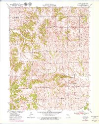
1950 Map of Coloma
USGS Topo · Published 1979About this map
Stokes Mound and several other prominent elevations rise above the rural landscapes of northern Carroll County on this survey, reflecting a region defined by high ridges and deep drainages. Small community life is anchored by locations such as Coloma and Mandeville, while the educational and spiritual needs of the era are visible through rural landmarks like Franklin Sch, Stagner Sch, and the New Salem Ch. The topography is particularly distinctive around the Tater Hill formations, including Long Tater Hill and Round Tater Hill, which overlook Tater Hill Creek.
Find a feature on this map
26 named features on this map. Tap any name to fly to it.
Don’t see what you’re looking for? This feature index may not catch every label — zoom into the map to look around manually.
Map Details
Editions of this 1950 Coloma Map
3 editions found
Other maps of this area

1889 · Lexington
USGS Topo · 1:125,000

1890 · Marshall
USGS Topo · 1:125,000

1892 · Marshall
USGS Topo · 1:125,000

1901 · Marshall
USGS Topo · 1:125,000

1924 · Dawn
USGS Topo · 1:62,500

1924 · Hale
USGS Topo · 1:62,500

1950 · Coloma
USGS Topo · 1:24,000

1950 · Plymouth
USGS Topo · 1:24,000

1951 · Utica
USGS Topo · 1:62,500

1951 · Hale
USGS Topo · 1:62,500