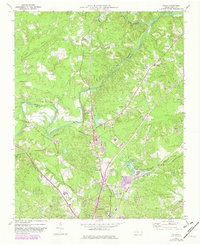
1970 Map of Colon
USGS Topo · Published 1982About this map
The Deep River and its confluence with the Rocky River define the northern landscape of this Lee County region as it appeared in the early 1970s. Industrial activity is concentrated near the settlement of Colon, where numerous claypits and a claypit indicate a reliance on local mineral extraction. This area is a significant rail junction, featuring the convergence of the Norfolk Southern, Southern, and Seaboard Coast Line railroads. These transit corridors linked rural communities like Asbury and Cumnock to the growing hub of Sanford. Local heritage is preserved in landmarks such as Taylors Ch, St Pauls Ch, and the Farmville Cem. Educational and recreational needs are marked by the Deep River High Sch and a local Golf Course, illustrating the community's transition from a strictly agrarian and industrial base toward modern development.
Find a feature on this map
37 named features on this map. Tap any name to fly to it.
Don’t see what you’re looking for? This feature index may not catch every label — zoom into the map to look around manually.
Map Details
Editions of this 1970 Colon Map
2 editions found
Other maps of this area

1953 · Raleigh
USGS Topo · 1:250,000

1954 · Raleigh
USGS Topo · 1:250,000

1969 · New Hope Dam
USGS Topo · 1:24,000

1970 · Goldston
USGS Topo · 1:24,000

1970 · Pittsboro
USGS Topo · 1:24,000

1970 · Colon
USGS Topo · 1:24,000

1970 · Moncure
USGS Topo · 1:24,000

1970 · Siler City NE
USGS Topo · 1:24,000

1974 · White Hill
USGS Topo · 1:24,000

1974 · Sanford
USGS Topo · 1:24,000