
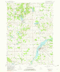
1963 Map of Columbiaville
USGS Topo · Published 1964About this map
Otter Lake and Columbiaville serve as the primary population centers in this rural landscape at the intersection of Lapeer, Genesee, and Tuscola counties. The area is defined by its extensive water systems, including the Holloway Reservoir along the Flint River and a dense network of agricultural drains like the Fostoria Drain and Kester Drain. Local transit and economy are tied to the New York Central Railroad, which bypasses the central lake district to connect the villages.
Find a feature on this map
54 named features on this map. Tap any name to fly to it.
Don’t see what you’re looking for? This feature index may not catch every label — zoom into the map to look around manually.
Map Details
Editions of this 1963 Columbiaville Map
2 editions found
Other maps of this area

1920 · Flint
USGS Topo · 1:62,500

1922 · Flint
USGS Topo · 1:62,500

1943 · Flint
USGS Topo · 1:62,500

1954 · Flint
USGS Topo · 1:250,000

1958 · Flint
USGS Topo · 1:250,000

1963 · Mayville
USGS Topo · 1:24,000

1963 · Elba
USGS Topo · 1:24,000

1963 · Vassar
USGS Topo · 1:24,000

1963 · Juniata
USGS Topo · 1:24,000
1963 · Barnes Lake
USGS Topo · 1:24,000