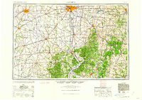
1962 Map of Columbus
USGS Topo · Published 1962About this map
Columbus serves as the focal point for this expansive regional study, where the industrial and transport networks of central and southern Ohio converge. The map illustrates a landscape shaped by significant river valleys, notably the Scioto River, Muskingum River, and Hocking River, which historically dictated the placement of major settlements like Chillicothe, Zanesville, and Athens. The era is defined by a robust railroad infrastructure, with lines from the Pennsylvania RR and Baltimore & Ohio RR lacing through the terrain, connecting agricultural hubs like Washington Court House and Wilmington to the growing capital.
Find a feature on this map
211 named features on this map. Tap any name to fly to it.
Don’t see what you’re looking for? This feature index may not catch every label — zoom into the map to look around manually.
Map Details
Editions of this 1962 Columbus Map
This is the sole edition of this map. No revisions or reprints were ever made.
Other maps of this area

1901 · Dublin
USGS Topo · 1:62,500

1902 · Westerville
USGS Topo · 1:62,500

1903 · Dublin
USGS Topo · 1:62,500

1903 · Athens
USGS Topo · 1:62,500

1904 · Westerville
USGS Topo · 1:62,500

1904 · Springfield
USGS Topo · 1:62,500
1904 · Zaleski
USGS Topo · 1:62,500
1904 · Dayton
USGS Topo · 1:62,500

1904 · Chesterhill
USGS Topo · 1:62,500

1905 · Athens
USGS Topo · 1:62,500