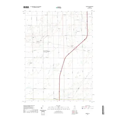
2021 Map of Compton
USGS Topo · Published 2021About this map
Compton serves as a central hub in this agricultural landscape of eastern Lee County, where the village's grid is defined by W Walnut St and W Cherry St. The surrounding countryside is dotted with small settlements like The Burg and Roxbury, alongside numerous rural burial grounds that speak to the area's pioneer roots, including Mélugin Grove Cem and the Brooklyn Lutheran Cem. The terrain is drained by a network of waterways such as Big Bureau Cr and Willow Cr, which meander through the prairie sections. Transport and local industry are marked by several private airstrips like W Davis Airport and Earl Barnickel Airport, reflecting the modern integration of aviation into this traditional farming district. The boundary with LaSalle County at the southern edge near Welland highlights the regional connectivity maintained by an extensive road network from Chicago Rd to Stainbrook Rd.
Find a feature on this map
49 named features on this map. Tap any name to fly to it.
Don’t see what you’re looking for? This feature index may not catch every label — zoom into the map to look around manually.
Map Details
Editions of this 2021 Compton Map
This is the sole edition of this map. No revisions or reprints were ever made.
Other maps of this area

1934 · De Kalb
USGS Topo · 1:62,500

1937 · De Kalb
USGS Topo · 1:62,500

1951 · Earlville
USGS Topo · 1:62,500

1952 · Rochelle
USGS Topo · 1:62,500

1952 · Mendota
USGS Topo · 1:62,500

1958 · Aurora
USGS Topo · 1:250,000

1961 · Aurora
USGS Topo · 1:250,000
1971 · Lee
USGS Topo · 1:24,000
1971 · Paw Paw
USGS Topo · 1:24,000
1971 · Earlville
USGS Topo · 1:24,000