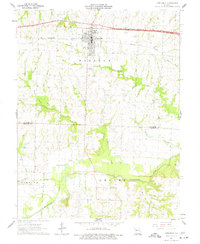
1962 Map of Concordia
USGS Topo · Published 1977About this map
Concordia serves as the primary hub of activity in this 1960s survey, centered around the St Pauls College campus and the industrial presence of the Missouri Pacific railroad. The town sits at a high point in Freedom township, overlooking a landscape defined by deeply incised drainages like Panther Creek and Peavine Creek that flow south toward the Blackwater River bottomlands. This southern portion of the map reveals a shift in land use, where the winding river creates features such as Horseshoe Lake and provides a location for a Gaging Station near the bridge over Walnut Creek. Genealogists will find significant value in the distribution of rural burial sites, including St Johns Cem to the northeast and Payne Cem further south. The map captures a moment of infrastructure expansion, notably with a section of road labeled as Under Constr cutting across the northern township line, signaling the arrival of modern highway transit to this agrarian region.
Find a feature on this map
29 named features on this map. Tap any name to fly to it.
Don’t see what you’re looking for? This feature index may not catch every label — zoom into the map to look around manually.
Map Details
Editions of this 1962 Concordia Map
3 editions found
Other maps of this area

1885 · Warrensburg
USGS Topo · 1:125,000

1887 · Sedalia
USGS Topo · 1:125,000

1887 · Warrensburg
USGS Topo · 1:125,000

1889 · Lexington
USGS Topo · 1:125,000

1890 · Marshall
USGS Topo · 1:125,000

1892 · Marshall
USGS Topo · 1:125,000

1894 · Sedalia
USGS Topo · 1:125,000

1894 · Warrensburg
USGS Topo · 1:125,000

1901 · Marshall
USGS Topo · 1:125,000

1917 · Knobnoster
USGS Topo · 1:62,500