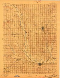
1892 Map of Concordia
USGS Topo · Published 1898About this map
The Republican River meanders through a landscape defined by an extensive web of late 19th-century railroads and river-bottom settlements. At the heart of the region, Concordia and Belleville serve as primary hubs where major lines like the Union Pacific Railway, Missouri Pacific Railway, and the Chicago Rock Island and Pacific Railway converge. This survey captures a moment when the prairie was being rapidly partitioned into townships such as Scandia, Liberty, and Beaver, reflecting the intense agrarian organization of the era.
Find a feature on this map
75 named features on this map. Tap any name to fly to it.
Don’t see what you’re looking for? This feature index may not catch every label — zoom into the map to look around manually.
Map Details
Editions of this 1892 Concordia Map
4 editions found
Other maps of this area

1891 · Clay Center
USGS Topo · 1:125,000

1892 · Concordia
USGS Topo · 1:125,000

1892 · Minneapolis
USGS Topo · 1:125,000

1893 · Washington
USGS Topo · 1:125,000

1894 · Mankato
USGS Topo · 1:125,000

1894 · Beloit
USGS Topo · 1:125,000

1898 · Superior
USGS Topo · 1:125,000

1898 · Hebron
USGS Topo · 1:125,000

1953 · Glasco NE
USGS Topo · 1:24,000

1953 · Simpson
USGS Topo · 1:24,000