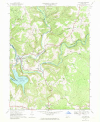
1967 Map of Confluence
USGS Topo · Published 1970About this map
Youghiogheny River Reservoir dominates the western landscape of this 1967 survey, where the Youghiogheny River meets the Casselman River at the town of Confluence. The mapping reveals a valley defined by the crossing of major railroads, with both the Baltimore and Ohio and the Western Maryland lines threading through the river gaps and tunnels. To the north and south, the townships of Lower Turkeyfoot and Addison are dotted with rural landmarks essential for genealogical research, including Jersey Ch, Patrons Ch, and the Younkin Cem.
Find a feature on this map
50 named features on this map. Tap any name to fly to it.
Don’t see what you’re looking for? This feature index may not catch every label — zoom into the map to look around manually.
Map Details
Editions of this 1967 Confluence Map
4 editions found
Other maps of this area

1899 · Grantsville
USGS Topo · 1:62,500

1900 · Accident
USGS Topo · 1:62,500

1904 · Grantsville
USGS Topo · 1:62,500

1921 · Meyersdale
USGS Topo · 1:62,500

1922 · Confluence
USGS Topo · 1:62,500

1931 · Confluence
USGS Topo · 1:62,500

1933 · Confluence
USGS Topo · 1:62,500

1939 · Meyersdale
USGS Topo · 1:62,500

1944 · Meyersdale
USGS Topo · 1:62,500

1946 · Grantsville
USGS Topo · 1:24,000
Featured Places
- Confluence, PA
- Ursina, PA
- Addison Township, PA
- Upper Turkeyfoot Township, PA
- Draketown, Lower Turkeyfoot Township