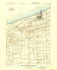
1906 Map of Conneaut
USGS Topo · Published 1950About this map
Conneaut serves as the industrial and transit focal point on the southern shore of Lake Erie, defined in the early twentieth century by its intricate rail network and lakeside harbor. The landscape is dominated by the winding paths of Conneaut Creek and the Ashtabula River, which cut through the townships of Kingsville, Monroe, and Sheffield. Major trunk lines, including the Lake Shore and Michigan Southern and the New York Chicago and St Louis, facilitate heavy transport through the region, while specialized routes like the L S and M S R R (Low Grade Cutoff) reflect the era's engineering efforts to manage freight movement along the Ohio Pennsylvania Boundary Line. Inland, small rural centers such as Kelloggsville, Pierpont, and Griggs Corners mark the agrarian character of Ashtabula County away from the industrial lakefront.
Find a feature on this map
47 named features on this map. Tap any name to fly to it.
Don’t see what you’re looking for? This feature index may not catch every label — zoom into the map to look around manually.
Map Details
Editions of this 1906 Conneaut Map
2 editions found
Other maps of this area

1900 · Girard
USGS Topo · 1:62,500

1900 · Fairview
USGS Topo · 1:62,500

1905 · Andover
USGS Topo · 1:48,000

1905 · Ashtabula
USGS Topo · 1:62,500

1905 · Jefferson
USGS Topo · 1:62,500

1906 · Conneaut
USGS Topo · 1:62,500

1906 · Linesville
USGS Topo · 1:62,500

1907 · Andover
USGS Topo · 1:62,500

1907 · Jefferson
USGS Topo · 1:62,500

1908 · Linesville
USGS Topo · 1:62,500