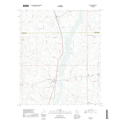
2018 Map of Converse
USGS Topo · Published 2018About this map
Converse sits at the heart of this North Louisiana landscape, where the boundary between De Soto Parish and Sabine Parish divides a region defined by dense bayou networks. The drainage of Bayou San Patricio dominates the central terrain, carving a wide path through the timbered hills between the smaller settlements of Benson to the north and Sardis to the south. Local transit is recorded through specific landmarks like Cotton Gin Rd and Old Camp Rd, which hint at the agricultural and timber history of the area. Genealogists will find the Sebastian Cem near the northern border, while the eastern edge of the map identifies the small community of Mitchell near Drake Lake. The intricate mapping of Choctaw Bayou and its numerous tributaries reveals a landscape where water and elevation have long dictated the placement of homesteads and connecting roads.
Find a feature on this map
66 named features on this map. Tap any name to fly to it.
Don’t see what you’re looking for? This feature index may not catch every label — zoom into the map to look around manually.
Map Details
Editions of this 2018 Converse Map
This is the sole edition of this map. No revisions or reprints were ever made.
Other maps of this area

1941 · Zwolle
USGS Topo · 1:62,500

1941 · Pelican
USGS Topo · 1:62,500

1943 · Pleasant Hill
USGS Topo · 1:62,500

1944 · Logansport
USGS Topo · 1:62,500

1944 · Patroon
USGS Topo · 1:62,500

1944 · Zwolle
USGS Topo · 1:62,500

1944 · Pleasant Hill
USGS Topo · 1:62,500

1953 · Alexandria
USGS Topo · 1:250,000

1955 · Alexandria
USGS Topo · 1:250,000

1956 · Logansport
USGS Topo · 1:62,500