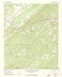
1962 Map of Cooks Springs
USGS Topo · Published 1973About this map
Cooks Springs serves as a focal point for this survey of the St. Clair and Shelby County borderlands, where the Southern railroad cuts through the ridge via the Cooks Springs Tunnel. The landscape is defined by the parallel elevations of Sand Mountain, Karr Mountain, and Oak Mountain, creating a corridor of narrow valleys and rural settlements. Family history is anchored at sites like Stewarts Cem near Stewarts Crossroads and Hollis Cem, while the spiritual life of the area is represented by Taylors Ch and Happy Home Ch. Heavy industry and utility infrastructure are evident through the Quarry near Acmar and prominent pipeline and telephone corridors. These features, along with the numerous small lakes like Hillhouse Lake and Schneider Lake, illustrate a mid-century Alabama landscape transitioning from traditional mountain agriculture toward industrial and institutional use, including the St Clair Nursing Home.
Find a feature on this map
73 named features on this map. Tap any name to fly to it.
Don’t see what you’re looking for? This feature index may not catch every label — zoom into the map to look around manually.
Map Details
Editions of this 1962 Cooks Springs Map
4 editions found
Other maps of this area

1889 · Springville
USGS Topo · 1:125,000

1889 · Birmingham
USGS Topo · 1:125,000

1890 · Bessemer
USGS Topo · 1:125,000

1890 · Talladega
USGS Topo · 1:125,000

1892 · Birmingham
USGS Topo · 1:125,000

1892 · Springville
USGS Topo · 1:125,000

1892 · Talladega
USGS Topo · 1:125,000

1892 · Bessemer
USGS Topo · 1:125,000

1895 · Birmingham
USGS Topo · 1:125,000

1905 · Leeds
USGS Topo · 1:62,500