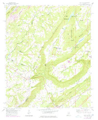
1958 Map of Hyatt Gap
USGS Topo · Published 1978About this map
Ferguson Crossroads and Whitney Junction anchor this mid-century look at the borderlands of Blount, Etowah, and St. Clair counties. The landscape is dominated by the dramatic parallel ridgelines of Blount Mountain and Chandler Mountain, creating deep natural features like Chandler Gulf and The Sink. These topographical barriers concentrated human activity into the lowlands of Greasy Cove and Beason Cove, where small communities supported institutions like Smith Chapel and Chandler Mountain Sch. The presence of numerous strip mines along Raccoon Mtn and Little Red Mountain reflects the region's industrial ties to coal extraction, while the development of Camp Sumatanga and its namesake Lake Sumatanga indicates a mid-century shift toward recreation and conservation alongside traditional mountain life.
Find a feature on this map
64 named features on this map. Tap any name to fly to it.
Don’t see what you’re looking for? This feature index may not catch every label — zoom into the map to look around manually.
Map Details
Editions of this 1958 Hyatt Gap Map
4 editions found
Other maps of this area

1885 · Gadsden
USGS Topo · 1:125,000

1888 · Gadsden
USGS Topo · 1:125,000

1889 · Springville
USGS Topo · 1:125,000

1892 · Springville
USGS Topo · 1:125,000

1892 · Gadsden
USGS Topo · 1:125,000

1895 · Gadsden
USGS Topo · 1:125,000

1903 · Gadsden
USGS Topo · 1:125,000

1947 · Cox Gap
USGS Topo · 1:24,000

1947 · Steele
USGS Topo · 1:24,000

1947 · Steele
USGS Topo · 1:62,500