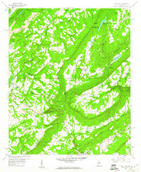
1958 Map of Hyatt Gap
USGS Topo · Published 1960About this map
Straight Mountain and Blount Mountain dominate this late-1950s landscape, framing the long agricultural corridor of Greasy Cove. The transition from valley farming to upland industry is evident in the Strip Mines and numerous unnamed mines that dot the ridges of Raccoon Mountain. Near Ferguson Crossroad, the rural character is defined by established community centers like Pleasant Valley Ch and Smith Chapel, while further south, the Southern Railway serves as a vital transport artery at Whitney Junction.
Find a feature on this map
61 named features on this map. Tap any name to fly to it.
Don’t see what you’re looking for? This feature index may not catch every label — zoom into the map to look around manually.
Map Details
Editions of this 1958 Hyatt Gap Map
4 editions found
Other maps of this area

1885 · Gadsden
USGS Topo · 1:125,000

1888 · Gadsden
USGS Topo · 1:125,000

1889 · Springville
USGS Topo · 1:125,000

1892 · Springville
USGS Topo · 1:125,000

1892 · Gadsden
USGS Topo · 1:125,000

1895 · Gadsden
USGS Topo · 1:125,000

1903 · Gadsden
USGS Topo · 1:125,000

1947 · Cox Gap
USGS Topo · 1:24,000

1947 · Steele
USGS Topo · 1:24,000

1947 · Steele
USGS Topo · 1:62,500