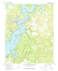
1972 Map of Cookson
USGS Topo · Published 1974About this map
Tenkiller Ferry Lake dominates this 1970s landscape, where the impounded Illinois River created an intricate network of inlets and bays like Pettit Bay and Carlisle Cove. The map documents a period of significant recreational development following the lake's creation, evidenced by numerous public use areas and boat ramps such as those at Sisemore Landing Public Use Area and Cookson Bend Public Use Area.
Find a feature on this map
54 named features on this map. Tap any name to fly to it.
Don’t see what you’re looking for? This feature index may not catch every label — zoom into the map to look around manually.
Map Details
Editions of this 1972 Cookson Map
3 editions found
Other maps of this area

1898 · Tahlequah
USGS Topo · 1:125,000

1901 · Muscogee
USGS Topo · 1:125,000

1901 · Tahlequah
USGS Topo · 1:125,000

1905 · Muscogee
USGS Topo · 1:125,000

1905 · Tahlequah
USGS Topo · 1:125,000

1946 · Fort Smith
USGS Topo · 1:250,000

1948 · Hulbert
USGS Topo · 1:62,500

1948 · Webbers Falls
USGS Topo · 1:62,500

1950 · Hulbert
USGS Topo · 1:62,500

1950 · Webbers Falls
USGS Topo · 1:62,500