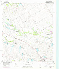
1965 Map of Coolidge
USGS Topo · Published 1978About this map
Coolidge serves as the primary hub in this Texas landscape, situated at the intersection of road networks and a rail corridor in Limestone County. This mid-century survey reveals a highly managed watershed characterized by a series of engineered water controls, including Dam No 10 and Dam No 6. These structures are part of a broader network of flood prevention and water storage across the drainage basins of Pin Oak Creek and Alligator Creek. The rural settlement pattern is anchored by small communities such as Munger, Calina, and Eldorado. Genealogy researchers will find interest in the isolated Dover Cem located near the North Fork of Pin Oak Creek, while the inclusion of the Athletic Field and Sewage Disposal facility in Coolidge indicates the town's local infrastructure during the mid-1960s.
Find a feature on this map
33 named features on this map. Tap any name to fly to it.
Don’t see what you’re looking for? This feature index may not catch every label — zoom into the map to look around manually.
Map Details
Editions of this 1965 Coolidge Map
2 editions found

Other maps of this area

1920 · Mart
USGS Topo · 1:62,500

1954 · Waco
USGS Topo · 1:250,000

1955 · Waco
USGS Topo · 1:250,000

1956 · Hubbard
USGS Topo · 1:24,000

1956 · Dawson
USGS Topo · 1:24,000

1957 · Irene
USGS Topo · 1:24,000

1957 · Prairie Hill
USGS Topo · 1:24,000

1957 · Groesbeck
USGS Topo · 1:62,500

1960 · Echols
USGS Topo · 1:24,000

1960 · Tehuacana
USGS Topo · 1:24,000