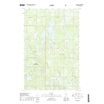
2019 Map of Coon Lake
USGS Topo · Published 2019About this map
Chippewa National Forest dominates this northern landscape, where an intricate network of glacial lakes and waterways defines the movement through the woods. The water-rich terrain includes significant bodies like Coon Lake, Sandwick Lake, and Pine Lake, connected by minor drainage systems such as Gale Brook and the Rice River. Settlement patterns are minimal, with the area primarily utilized for recreation and resource management. The 2019 survey shows modern infrastructure tailored for outdoor access, notably the Cameron Lake Snowmobile Trail and seasonal access routes like Marie Lake Rd and Bakke Rd. The presence of the Scenic Hwy cutting through the forest indicates the primary transit corridor for this remote section of Itasca County, providing access to the numerous named lakes like Isaac Lake and Lake of Isles that dot the interior.
Find a feature on this map
52 named features on this map. Tap any name to fly to it.
Don’t see what you’re looking for? This feature index may not catch every label — zoom into the map to look around manually.
Map Details
Editions of this 2019 Coon Lake Map
This is the sole edition of this map. No revisions or reprints were ever made.
Other maps of this area

1919 · Release
USGS Topo · 1:62,500

1919 · Marcell
USGS Topo · 1:62,500

1943 · Release
USGS Topo · 1:62,500

1954 · Hibbing
USGS Topo · 1:250,000

1957 · Hibbing
USGS Topo · 1:250,000

1958 · Hibbing
USGS Topo · 1:250,000

1964 · Hibbing
USGS Topo · 1:250,000

1970 · Clubhouse Lake
USGS Topo · 1:24,000

1970 · Coon Lake
USGS Topo · 1:24,000
1970 · Anderson Lake
USGS Topo · 1:24,000