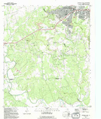
1995 Map of Copperas Cove
USGS Topo · Published 1995About this map
Copperas Cove sits at a geographic and political crossroads where Coryell, Lampasas, and Bell counties meet. In the mid-1990s, the city's expansion is evident along the northern edge of the map, while the eastern boundary is defined by the Fort Hood Military Reservation Boundary. The landscape is shaped by the transition from the rolling Texas Hill Country to the limestone plateaus, marked by prominent landmarks like Ogletree Gap, Taylor Mountain, and Sevenmile Mountain. This period shows a complex mix of suburban growth, including numerous Mobile Home Parks, alongside established rural traditions. Family histories are preserved in scattered burial grounds such as Smith Cem and Ethridge Cem, while the southern reaches follow the winding course of the Lampasas River near Burnet Falls.
Find a feature on this map
48 named features on this map. Tap any name to fly to it.
Don’t see what you’re looking for? This feature index may not catch every label — zoom into the map to look around manually.
Map Details
Editions of this 1995 Copperas Cove Map
This is the sole edition of this map. No revisions or reprints were ever made.
Other maps of this area

1887 · Lampasas
USGS Topo · 1:125,000

1887 · Burnet
USGS Topo · 1:125,000

1893 · Georgetown
USGS Topo · 1:125,000

1893 · Burnet
USGS Topo · 1:125,000

1894 · Lampasas
USGS Topo · 1:125,000

1894 · Gatesville
USGS Topo · 1:125,000

1903 · Burnet
USGS Topo · 1:125,000

1909 · Burnet
USGS Topo · 1:125,000

1947 · Fort Hood
USGS Topo · 1:62,500

1947 · Fort Hood
USGS Topo · 1:24,000