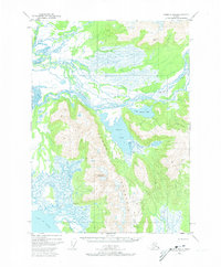
1950 Map of Cordova B-2
USGS Topo · Published 1973About this map
Martin River dominates this 1950s aerial survey, its braided channels and vast glacial outwash plains creating a complex delta system before reaching the Gulf of Alaska. The landscape is defined by the massive aquatic features of Martin Lake and Little Martin Lake, which sit at the base of the towering Ragged Mountain. This region, surveyed before any significant modern development, shows an environment shaped by water, with the Martin River Slough and Mirror Slough winding through coastal wetlands. Human presence is exceptionally sparse, marked primarily by the Bennett Rock Cabin 26 near the river's mouth. The map also records several high-altitude survey markers, including VABM Rocky 3315 and VABM Mar 2298, serving as vital triangulation points for mapping this difficult terrain along the Katalla River and Clear Creek.
Find a feature on this map
14 named features on this map. Tap any name to fly to it.
Don’t see what you’re looking for? This feature index may not catch every label — zoom into the map to look around manually.
Map Details
Editions of this 1950 Cordova B-2 Map
4 editions found
Other maps of this area

1948 · Cordova
USGS Topo · 1:250,000

1950 · Cordova B-2
USGS Topo · 1:63,360

1950 · Cordova A-1
USGS Topo · 1:63,360

1950 · Cordova A-2
USGS Topo · 1:63,360

1951 · Cordova
USGS Topo · 1:250,000

1951 · Cordova B-1
USGS Topo · 1:63,360

1951 · Cordova C-3
USGS Topo · 1:63,360

1952 · Cordova B-3
USGS Topo · 1:63,360

1953 · Cordova A-2
USGS Topo · 1:63,360

1953 · Cordova B-1
USGS Topo · 1:63,360